
Gelsenkirchen
45899 Gelsenkirchen-Nord, Deutschland
Rungenberghalde | Parking & Stairs
The Rungenberghalde in Gelsenkirchen-Buer is much more than a grassy hill on the outskirts of the city. It is a deliberately shaped spoil tip above the former Hugo mine, a visible sign of mining history and at the same time a local recreation area that still differs significantly from the industrial backdrop of the Ruhr area. Characteristic are the two pyramid-like peaks, the open clearing between the ascents, and the light installation Nachtzeichen, which gives the hill a nearly symbolic effect at night. Those who come here experience a place where landscape, art, and mining history are closely intertwined. This mix makes the Rungenberghalde exciting for walks, photo tours, and short trips. It is located in close proximity to the Schüngelberg settlement and is thus also urbanistically closely linked to the history of the district. ([gelsenkirchen.de](https://www.gelsenkirchen.de/de/Freizeit/Ausfluege_und_Sehenswuerdigkeiten/Parks_und_Halden/Halde_Rungenberg.aspx?utm_source=openai))
Parking and Access to the Rungenberghalde
Anyone wishing to visit the Rungenberghalde should plan their approach carefully, as the site is not a classic event center with large visitor parking garages, but a hill that is accessed via paths from the surrounding neighborhood. The official address is Rungenbergstraße in 45897 Gelsenkirchen, and the city describes access primarily via the Schüngelberg settlement and Horster Straße. This is important because the paths are not oriented towards a wide, centralized driveway, but rather have the character of an urban walking and excursion area. For visitors, this means: Plan your approach with a sense of orientation, pay attention to signage, and choose the starting point so that the ascent fits well into your personal route. ([gelsenkirchen.de](https://www.gelsenkirchen.de/de/freizeit/ausfluege_und_sehenswuerdigkeiten/parks_und_halden/halde_rungenberg.aspx?utm_source=openai))
As a practical point of orientation, the parking lot on Rungenbergstraße or at Heinz-Günther-Breuker-Weg appears in urban event notices. This shows that there are indeed nearby parking options, which should be understood more as a local meeting point rather than a large parking facility. Therefore, those arriving by car are well advised to start early, especially on weekends or in good weather. For the visitor experience, this somewhat restrained access can even be an advantage: You approach the hill more slowly, notice the transition from the residential area to the open landscape, and experience the contrast between city and nature even on the way. This is part of the appeal of this place. ([gelsenkirchen.de](https://www.gelsenkirchen.de/de/bildung/ausserschulische_bildung/umweltbildung/umweltdiplom/anmeldung.aspx?utm_source=openai))
The access from the Schüngelberg settlement is the most atmospheric. The city describes a direct path over a bridge and stairway, and this entrance visibly connects the hill with the historic residential area at the foot of the mountain. Those coming from Horster Straße experience the hill more through winding paths. Both variants have their own character: One path stages the ascent almost like a conscious transition from the settlement to a landscape architecture, while the other emphasizes the soft, landscape integration. For orientation, both accesses are helpful, as they show that the Rungenberghalde is not an isolated point but is embedded in a developed urban structure. ([gelsenkirchen.de](https://www.gelsenkirchen.de/de/freizeit/ausfluege_und_sehenswuerdigkeiten/parks_und_halden/halde_rungenberg.aspx?utm_source=openai))
Stairs, Paths, and the Ascent to the Hill
The ascent to the Rungenberghalde is a central feature of the visit. The city and the Route of Industrial Culture describe numerous winding paths that stretch upwards from Schüngelberg or Horster Straße. For those who prefer a more direct route, there is the well-known stairway from the Schüngelberg settlement. This mix of a cozy serpentine path and a compact stair route makes the hill attractive for different visitor groups. The path is not designed for speed but for a conscious transition to height. Those who ascend feel very clearly that the hill is not just a viewpoint but also a designed space. This is typical for many places of industrial culture, but particularly clear at the Rungenberghalde. ([gelsenkirchen.de](https://www.gelsenkirchen.de/de/freizeit/ausfluege_und_sehenswuerdigkeiten/parks_und_halden/halde_rungenberg.aspx?utm_source=openai))
A municipal press release mentions around 300 steps for the stairs on the Rungenberghalde. This number explains why the ascent is certainly doable but by no means trivial. The stairs are not a sports mountain, but they require a minimum of fitness and, above all, attention. Those taking the direct ascent should wear sturdy footwear, as the official city event around the hill visit also recommends weatherproof clothing and robust shoes. This transforms the visit into a small hike rather than just a photo stop. The ascent feels surprisingly intense on short paths because it quickly bridges the distance between everyday life in the valley and the special topography of the hill. ([gelsenkirchen.de](https://www.gelsenkirchen.de/de/freizeit/ausfluege_und_sehenswuerdigkeiten/parks_und_halden/halde_rungenberg.aspx?utm_source=openai))
Architecturally, the path is also significant. The connection between the settlement and the hill is not coincidental but is explicitly emphasized in the art and city description. The most direct access leads over a bridge and a stairway, with the axis of the clearing continuing on the hilltop. This creates a clear sightline that makes the artificial form of the place readable. The ascent is therefore not only practical but also a design part of the overall concept. Those who go up quickly realize: The path to the top is part of the narrative. You do not simply ascend; you follow a deliberately set line that connects the settlement, the hill, and the light art. ([gelsenkirchen.de](https://www.gelsenkirchen.de/de/kultur/bildende_kunst__literatur__tanz/kunst_im_oeffentlichen_raum/karte/poi/2386-noculak-klaus-esrichter-hermann-nachtzeichen?utm_source=openai))
Height, Summit, and Panorama over Gelsenkirchen
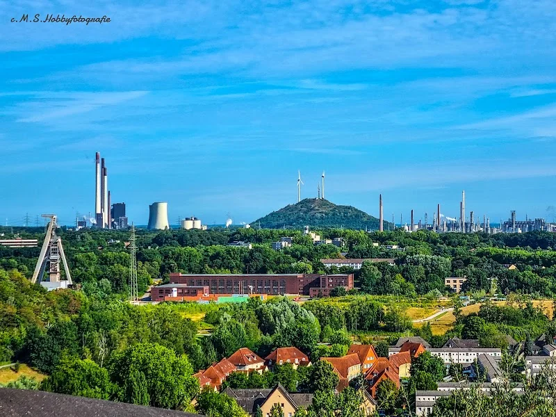
The Rungenberghalde is approximately 63 hectares in size and about 60 meters high. These figures may initially sound dry, but they explain very well why the hill appears so prominent in the urban area. It is one of the larger spoil tips in the Ruhr area and shapes the northern part of Gelsenkirchen as a clearly visible landmark. The summit area is not shaped as a naturally grown hilltop but as a deliberate geometric structure with two peaks. This shape makes the hill so distinctive: it appears both massive and constructed, raw and composed. This is no coincidence but part of a concept that aimed to make the artificiality of the post-mining landscape visible. Therefore, when one climbs the hill, they experience not only an elevation gain but also a very clear architectural gesture. ([route-industriekultur.ruhr](https://www.route-industriekultur.ruhr/panoramen/halde-rungenberg/?utm_source=openai))
The panorama is one of the main reasons for the visit. The city describes the view from the hill ridge as rewarding, and during an urban hiking tour, the ascent is explicitly associated with an impressive panorama over the Ruhr area. From above, views open up over Gelsenkirchen, the surrounding districts, and the large-scale structure of the region. Especially because the hill is not isolated in the landscape but embedded in a dense urban and industrial structure, the view is particularly interesting: you see not only expanses but also the layering of settlements, traffic axes, green corridors, and industrial relics. The panorama is therefore not just beautiful but also readable. It shows how closely urban development and mining history are interconnected here. ([gelsenkirchen.de](https://www.gelsenkirchen.de/de/_meta/veranstaltungskalender/94829-sondertour-urban-hiking-die-wandertour-durch-gelsenkirchen-i?utm_source=openai))
The structure of the hilltop also contributes to the panorama experience. Two pyramids rise from the spoil material and form a double peak that gives the landscape an almost graphic character. This shape automatically directs the gaze along the clearing and out into the surroundings. Those who stay up there notice that the place is open but not arbitrary. The lines are strict enough to provide orientation and free enough to let the expanse of the Ruhr area come into play. For this reason, the Rungenberghalde is often perceived as a viewpoint, even though it is actually a designed industrial hill. The panorama here is therefore not just a natural view but also a result of planning, material, and mining history. ([route-industriekultur.ruhr](https://www.route-industriekultur.ruhr/panoramen/halde-rungenberg/?utm_source=openai))
Photos, Perspectives, and the Best Effect of the Rungenberghalde
The Rungenberghalde is particularly interesting for photos because it offers strong contrasts. Dark spoil material, open clearings, the two peaks of the hill, and a wide sky create a composition that almost works by itself. Unlike many classic viewpoints, it is not just about the distance but also about the form of the place itself. The hill is photogenic because its silhouette remains clearly recognizable and because the place has a very high recognition value. Those taking pictures can work with lines, contrasts, and perspectives without having to search long for motifs. The view along the clearing is particularly impressive because it emphasizes the artificial structure of the hill while simultaneously incorporating the surroundings. ([route-industriekultur.ruhr](https://www.route-industriekultur.ruhr/panoramen/halde-rungenberg/?utm_source=openai))
Additionally, the Rungenberghalde does not only have an effect during the day. The official city portal points out that the light installation is visible from a great distance, even from the A2. This significantly changes the photographic effect in the evening and at dusk. The Nachtzeichen complements the dark form of the hill with an artificial light image that virtually extends the peak. For photos, this means: There is not only the classic hill panorama in daylight but also a very distinctive nighttime imagery. Therefore, those photographing the hill can capture both the industrial aesthetics and the light art. The place is thus suitable for very different motifs, from wide landscape shots to focused detail images of the light installation. ([gelsenkirchen.de](https://www.gelsenkirchen.de/de/_meta/aktuelles/artikel/38723-nachtzeichen-mit-neuem-licht?utm_source=openai))
The connection to the Schüngelberg settlement also makes many shots more exciting. The hill is not located somewhere in the void but at the edge of a historically grown district. This creates perspectives where residential buildings, stairways, and the hilltop can appear together in one image. This connection is particularly narratively strong because it makes the transformation from a mining area to a cultural and recreational space visible. Therefore, anyone looking for images that tell more than just a beautiful view will find plenty of material here. The Rungenberghalde is thus a place that does not appear decorative in photos but rather characterful. It remains well readable as a landscape sign, even when viewed from different angles. ([gelsenkirchen.de](https://www.gelsenkirchen.de/de/kultur/bildende_kunst__literatur__tanz/kunst_im_oeffentlichen_raum/karte/poi/2386-noculak-klaus-esrichter-hermann-nachtzeichen?utm_source=openai))
Rungenberghalde at Night: Nachtzeichen and Light Art
The Nachtzeichen is the visual signature of the Rungenberghalde. The light installation was mounted in 1999 as part of the International Building Exhibition Emscher Park on the hill and was created by Hermann EsRichter and Klaus Noculak. Two mirror spotlights are positioned so that their beams intersect above the center of the clearing, thus completing the imaginary hilltop. This is a simple but very powerful idea: the physical hill receives a virtual enhancement from light. This creates an effect in the evening that goes far beyond mere illumination. The hill becomes a landmark that connects art and topography. ([gelsenkirchen.de](https://www.gelsenkirchen.de/de/_meta/aktuelles/artikel/38723-nachtzeichen-mit-neuem-licht?utm_source=openai))
The city describes the Nachtzeichen as a well-known landmark motif of the Ruhr area, and in the recent technical renewal, the light effect has been switched to LED technology. This also shows how seriously the maintenance of this place is taken. The installation is not a static monument but a maintained light object that is intended to continue to have an effect. Particularly interesting is that the artificial light point does not obscure the shape of the hill but complements it. The darkness of the peak remains recognizable, but the beams draw an invisible line above it. For evening visits, this creates a very special impression: the hill appears both real and staged, industrial and poetic, heavy and light. The night thus enhances not only the atmosphere but also the readability of the place. ([gelsenkirchen.de](https://www.gelsenkirchen.de/de/_meta/aktuelles/artikel/38723-nachtzeichen-mit-neuem-licht?utm_source=openai))
The spatial context is also important. The city points out that the most direct way to the Nachtzeichen leads over a bridge and a stairway from the Schüngelberg settlement. This means that the night motif is not understood as an isolated work of art but as the conclusion of a clear path movement. Those who ascend experience the light installation as the endpoint of a line, not as random decoration. In connection with its visibility from the A2, the object also gains a regional dimension: it is not only significant on-site but also serves as a signal for passersby. This makes the hill at night a place that has an effect in just a few seconds and yet remains long in memory. ([gelsenkirchen.de](https://www.gelsenkirchen.de/de/_meta/aktuelles/artikel/38723-nachtzeichen-mit-neuem-licht?utm_source=openai))
History of the Rungenberghalde and the Hugo Mine
The history of the Rungenberghalde is closely linked to mining. The hill was created from spoil material from the Hugo mine and shaped as a prominent landscape body in the urban area of Gelsenkirchen-Buer. Its current form is due to Swiss architect Rolf Keller and the planning office Peter Drecker, who deliberately developed a clear, geometric shape. The goal was not to create a naturally appearing elevation but to make the artificiality of the post-mining landscape visible. This openness makes the hill so interesting today: it tells not only of recultivation but also of design. The hill itself is thus a document of the transformation of the Ruhr area. ([route-industriekultur.ruhr](https://www.route-industriekultur.ruhr/panoramen/halde-rungenberg/?utm_source=openai))
The artistic enhancement of the hill came in the 1990s. In addition to the Nachtzeichen, the clear clearing between the two peaks primarily shapes the image. The city emphasizes that the competition for artistic design involved many artists from the Ruhr area. This made the hill part of a larger cultural process in which mining sites were not only recultivated but also newly interpreted. The combination of industry, art, and recreational space is typical for the region but is particularly well recognized at the Rungenberghalde. It shows how a spoil tip can become a place with its own identity. This is not just a mere repurposing but a conscious re-staging of the existing. ([gelsenkirchen.de](https://www.gelsenkirchen.de/de/kultur/bildende_kunst__literatur__tanz/kunst_im_oeffentlichen_raum/karte/poi/2386-noculak-klaus-esrichter-hermann-nachtzeichen?utm_source=openai))
The surrounding area continues this story. At the foot of the hill lies the Schüngelberg settlement, which was complemented by new miners' housing as part of the International Building Exhibition Emscher Park. The city describes the settlement as the latest example of workers' housing in Gelsenkirchen, and this neighborhood makes the Rungenberghalde so convincing. The hill and the settlement together form a kind of open-air exhibition of urban and mining history. The visit becomes deeper because one does not only ascend the hill but perceives a historical ensemble. The mine has long been closed, but its imprint remains present in the landscape and architecture. ([gelsenkirchen.de](https://www.gelsenkirchen.de/de/freizeit/ausfluege_und_sehenswuerdigkeiten/architektur/werkssiedlungen/index.aspx?utm_source=openai))
Schüngelberg Settlement, Walks, and Visiting Tips
To truly understand the Rungenberghalde, one should consider the connection with the Schüngelberg settlement. The city describes the direct path over a bridge and a stairway from there, and this access is more than just practical. It makes visible that the hill and the residential area belong together. The settlement lies at the foot of the hill, and the paths upwards follow a clear urban planning idea. This makes the ascent a small journey through the history of the district. Those coming from the residential area experience not only elevation but also a spatial narrative: below, the life of the miners' settlement; above, the hill as a symbol of mining and change. ([gelsenkirchen.de](https://www.gelsenkirchen.de/de/kultur/bildende_kunst__literatur__tanz/kunst_im_oeffentlichen_raum/karte/poi/2386-noculak-klaus-esrichter-hermann-nachtzeichen?utm_source=openai))
The hill is very well suited for walks and hikes because it is embedded in larger green and cultural contexts. The city assigns it to the Emscher Landscape Park and the Regional Greenway C, which extends over several significant locations in western Gelsenkirchen. This means: The Rungenberghalde is not an isolated object but part of a network of green spaces, industrial culture, and urban landscape. For visitors, this is ideal if a short hill visit is to become a longer round trip. The urban hiking tour to the hill also shows that the place can be easily integrated into urban hikes. Those who bring sturdy footwear and weatherproof clothing are well prepared for the ascent and the subsequent view. ([gelsenkirchen.de](https://www.gelsenkirchen.de/de/Freizeit/Ausfluege_und_Sehenswuerdigkeiten/Emscher_Landschaftspark/?utm_source=openai))
As a destination, the Rungenberghalde convinces precisely through its mix of simplicity and intensity. You do not need long preparation to experience the place, but you should take your time so that the effect of the paths, the stairs, the hill shape, and the panorama comes together. The hill works as a short excursion as well as part of a larger route through Gelsenkirchen-Buer. Those who look closely will recognize that many layers overlap here: mining history, settlement construction, light art, landscape planning, and recreational use. This is precisely what keeps the place alive. The Rungenberghalde is not just a hill with a view but a condensed piece of the Ruhr area that unfolds step by step. ([route-industriekultur.ruhr](https://www.route-industriekultur.ruhr/panoramen/halde-rungenberg/?utm_source=openai))
Sources:
- City of Gelsenkirchen - Halde Rungenberg ([gelsenkirchen.de](https://www.gelsenkirchen.de/de/Freizeit/Ausfluege_und_Sehenswuerdigkeiten/Parks_und_Halden/Halde_Rungenberg.aspx?utm_source=openai))
- Route of Industrial Culture - Halde Rungenberg ([route-industriekultur.ruhr](https://www.route-industriekultur.ruhr/panoramen/halde-rungenberg/?utm_source=openai))
- City of Gelsenkirchen - Nachtzeichen with new light ([gelsenkirchen.de](https://www.gelsenkirchen.de/de/_meta/aktuelles/artikel/38723-nachtzeichen-mit-neuem-licht?utm_source=openai))
- City of Gelsenkirchen - Map Details: Nachtzeichen ([gelsenkirchen.de](https://www.gelsenkirchen.de/de/kultur/bildende_kunst__literatur__tanz/kunst_im_oeffentlichen_raum/karte/poi/2386-noculak-klaus-esrichter-hermann-nachtzeichen?utm_source=openai))
- City of Gelsenkirchen - Treasure House Staircase ([gelsenkirchen.de](https://www.gelsenkirchen.de/de/_funktionsnavigation/presse/pressemeldungen/10192-schatzhaus-treppenhaus?utm_source=openai))
- City of Gelsenkirchen - Emscher Landscape Park and Regional Greenway C ([gelsenkirchen.de](https://www.gelsenkirchen.de/de/Freizeit/Ausfluege_und_Sehenswuerdigkeiten/Emscher_Landschaftspark/?utm_source=openai))
- City of Gelsenkirchen - Factory Settlements / Schüngelberg Settlement ([gelsenkirchen.de](https://www.gelsenkirchen.de/de/freizeit/ausfluege_und_sehenswuerdigkeiten/architektur/werkssiedlungen/index.aspx?utm_source=openai))
- City of Gelsenkirchen - the small museum & Zeche Hugo ([gelsenkirchen.de](https://www.gelsenkirchen.de/de/Kultur/Museen_und_Dauerausstellungen/das_kleine_museum___Zeche_Hugo/index.aspx?utm_source=openai))
- City of Gelsenkirchen - Urban Hiking to the Halde Rungenberg ([gelsenkirchen.de](https://www.gelsenkirchen.de/de/_meta/veranstaltungskalender/94829-sondertour-urban-hiking-die-wandertour-durch-gelsenkirchen-i?utm_source=openai))
Mehr anzeigenWeniger anzeigen
Rungenberghalde | Parking & Stairs
The Rungenberghalde in Gelsenkirchen-Buer is much more than a grassy hill on the outskirts of the city. It is a deliberately shaped spoil tip above the former Hugo mine, a visible sign of mining history and at the same time a local recreation area that still differs significantly from the industrial backdrop of the Ruhr area. Characteristic are the two pyramid-like peaks, the open clearing between the ascents, and the light installation Nachtzeichen, which gives the hill a nearly symbolic effect at night. Those who come here experience a place where landscape, art, and mining history are closely intertwined. This mix makes the Rungenberghalde exciting for walks, photo tours, and short trips. It is located in close proximity to the Schüngelberg settlement and is thus also urbanistically closely linked to the history of the district. ([gelsenkirchen.de](https://www.gelsenkirchen.de/de/Freizeit/Ausfluege_und_Sehenswuerdigkeiten/Parks_und_Halden/Halde_Rungenberg.aspx?utm_source=openai))
Parking and Access to the Rungenberghalde
Anyone wishing to visit the Rungenberghalde should plan their approach carefully, as the site is not a classic event center with large visitor parking garages, but a hill that is accessed via paths from the surrounding neighborhood. The official address is Rungenbergstraße in 45897 Gelsenkirchen, and the city describes access primarily via the Schüngelberg settlement and Horster Straße. This is important because the paths are not oriented towards a wide, centralized driveway, but rather have the character of an urban walking and excursion area. For visitors, this means: Plan your approach with a sense of orientation, pay attention to signage, and choose the starting point so that the ascent fits well into your personal route. ([gelsenkirchen.de](https://www.gelsenkirchen.de/de/freizeit/ausfluege_und_sehenswuerdigkeiten/parks_und_halden/halde_rungenberg.aspx?utm_source=openai))
As a practical point of orientation, the parking lot on Rungenbergstraße or at Heinz-Günther-Breuker-Weg appears in urban event notices. This shows that there are indeed nearby parking options, which should be understood more as a local meeting point rather than a large parking facility. Therefore, those arriving by car are well advised to start early, especially on weekends or in good weather. For the visitor experience, this somewhat restrained access can even be an advantage: You approach the hill more slowly, notice the transition from the residential area to the open landscape, and experience the contrast between city and nature even on the way. This is part of the appeal of this place. ([gelsenkirchen.de](https://www.gelsenkirchen.de/de/bildung/ausserschulische_bildung/umweltbildung/umweltdiplom/anmeldung.aspx?utm_source=openai))
The access from the Schüngelberg settlement is the most atmospheric. The city describes a direct path over a bridge and stairway, and this entrance visibly connects the hill with the historic residential area at the foot of the mountain. Those coming from Horster Straße experience the hill more through winding paths. Both variants have their own character: One path stages the ascent almost like a conscious transition from the settlement to a landscape architecture, while the other emphasizes the soft, landscape integration. For orientation, both accesses are helpful, as they show that the Rungenberghalde is not an isolated point but is embedded in a developed urban structure. ([gelsenkirchen.de](https://www.gelsenkirchen.de/de/freizeit/ausfluege_und_sehenswuerdigkeiten/parks_und_halden/halde_rungenberg.aspx?utm_source=openai))
Stairs, Paths, and the Ascent to the Hill
The ascent to the Rungenberghalde is a central feature of the visit. The city and the Route of Industrial Culture describe numerous winding paths that stretch upwards from Schüngelberg or Horster Straße. For those who prefer a more direct route, there is the well-known stairway from the Schüngelberg settlement. This mix of a cozy serpentine path and a compact stair route makes the hill attractive for different visitor groups. The path is not designed for speed but for a conscious transition to height. Those who ascend feel very clearly that the hill is not just a viewpoint but also a designed space. This is typical for many places of industrial culture, but particularly clear at the Rungenberghalde. ([gelsenkirchen.de](https://www.gelsenkirchen.de/de/freizeit/ausfluege_und_sehenswuerdigkeiten/parks_und_halden/halde_rungenberg.aspx?utm_source=openai))
A municipal press release mentions around 300 steps for the stairs on the Rungenberghalde. This number explains why the ascent is certainly doable but by no means trivial. The stairs are not a sports mountain, but they require a minimum of fitness and, above all, attention. Those taking the direct ascent should wear sturdy footwear, as the official city event around the hill visit also recommends weatherproof clothing and robust shoes. This transforms the visit into a small hike rather than just a photo stop. The ascent feels surprisingly intense on short paths because it quickly bridges the distance between everyday life in the valley and the special topography of the hill. ([gelsenkirchen.de](https://www.gelsenkirchen.de/de/freizeit/ausfluege_und_sehenswuerdigkeiten/parks_und_halden/halde_rungenberg.aspx?utm_source=openai))
Architecturally, the path is also significant. The connection between the settlement and the hill is not coincidental but is explicitly emphasized in the art and city description. The most direct access leads over a bridge and a stairway, with the axis of the clearing continuing on the hilltop. This creates a clear sightline that makes the artificial form of the place readable. The ascent is therefore not only practical but also a design part of the overall concept. Those who go up quickly realize: The path to the top is part of the narrative. You do not simply ascend; you follow a deliberately set line that connects the settlement, the hill, and the light art. ([gelsenkirchen.de](https://www.gelsenkirchen.de/de/kultur/bildende_kunst__literatur__tanz/kunst_im_oeffentlichen_raum/karte/poi/2386-noculak-klaus-esrichter-hermann-nachtzeichen?utm_source=openai))
Height, Summit, and Panorama over Gelsenkirchen
The Rungenberghalde is approximately 63 hectares in size and about 60 meters high. These figures may initially sound dry, but they explain very well why the hill appears so prominent in the urban area. It is one of the larger spoil tips in the Ruhr area and shapes the northern part of Gelsenkirchen as a clearly visible landmark. The summit area is not shaped as a naturally grown hilltop but as a deliberate geometric structure with two peaks. This shape makes the hill so distinctive: it appears both massive and constructed, raw and composed. This is no coincidence but part of a concept that aimed to make the artificiality of the post-mining landscape visible. Therefore, when one climbs the hill, they experience not only an elevation gain but also a very clear architectural gesture. ([route-industriekultur.ruhr](https://www.route-industriekultur.ruhr/panoramen/halde-rungenberg/?utm_source=openai))
The panorama is one of the main reasons for the visit. The city describes the view from the hill ridge as rewarding, and during an urban hiking tour, the ascent is explicitly associated with an impressive panorama over the Ruhr area. From above, views open up over Gelsenkirchen, the surrounding districts, and the large-scale structure of the region. Especially because the hill is not isolated in the landscape but embedded in a dense urban and industrial structure, the view is particularly interesting: you see not only expanses but also the layering of settlements, traffic axes, green corridors, and industrial relics. The panorama is therefore not just beautiful but also readable. It shows how closely urban development and mining history are interconnected here. ([gelsenkirchen.de](https://www.gelsenkirchen.de/de/_meta/veranstaltungskalender/94829-sondertour-urban-hiking-die-wandertour-durch-gelsenkirchen-i?utm_source=openai))
The structure of the hilltop also contributes to the panorama experience. Two pyramids rise from the spoil material and form a double peak that gives the landscape an almost graphic character. This shape automatically directs the gaze along the clearing and out into the surroundings. Those who stay up there notice that the place is open but not arbitrary. The lines are strict enough to provide orientation and free enough to let the expanse of the Ruhr area come into play. For this reason, the Rungenberghalde is often perceived as a viewpoint, even though it is actually a designed industrial hill. The panorama here is therefore not just a natural view but also a result of planning, material, and mining history. ([route-industriekultur.ruhr](https://www.route-industriekultur.ruhr/panoramen/halde-rungenberg/?utm_source=openai))
Photos, Perspectives, and the Best Effect of the Rungenberghalde
The Rungenberghalde is particularly interesting for photos because it offers strong contrasts. Dark spoil material, open clearings, the two peaks of the hill, and a wide sky create a composition that almost works by itself. Unlike many classic viewpoints, it is not just about the distance but also about the form of the place itself. The hill is photogenic because its silhouette remains clearly recognizable and because the place has a very high recognition value. Those taking pictures can work with lines, contrasts, and perspectives without having to search long for motifs. The view along the clearing is particularly impressive because it emphasizes the artificial structure of the hill while simultaneously incorporating the surroundings. ([route-industriekultur.ruhr](https://www.route-industriekultur.ruhr/panoramen/halde-rungenberg/?utm_source=openai))
Additionally, the Rungenberghalde does not only have an effect during the day. The official city portal points out that the light installation is visible from a great distance, even from the A2. This significantly changes the photographic effect in the evening and at dusk. The Nachtzeichen complements the dark form of the hill with an artificial light image that virtually extends the peak. For photos, this means: There is not only the classic hill panorama in daylight but also a very distinctive nighttime imagery. Therefore, those photographing the hill can capture both the industrial aesthetics and the light art. The place is thus suitable for very different motifs, from wide landscape shots to focused detail images of the light installation. ([gelsenkirchen.de](https://www.gelsenkirchen.de/de/_meta/aktuelles/artikel/38723-nachtzeichen-mit-neuem-licht?utm_source=openai))
The connection to the Schüngelberg settlement also makes many shots more exciting. The hill is not located somewhere in the void but at the edge of a historically grown district. This creates perspectives where residential buildings, stairways, and the hilltop can appear together in one image. This connection is particularly narratively strong because it makes the transformation from a mining area to a cultural and recreational space visible. Therefore, anyone looking for images that tell more than just a beautiful view will find plenty of material here. The Rungenberghalde is thus a place that does not appear decorative in photos but rather characterful. It remains well readable as a landscape sign, even when viewed from different angles. ([gelsenkirchen.de](https://www.gelsenkirchen.de/de/kultur/bildende_kunst__literatur__tanz/kunst_im_oeffentlichen_raum/karte/poi/2386-noculak-klaus-esrichter-hermann-nachtzeichen?utm_source=openai))
Rungenberghalde at Night: Nachtzeichen and Light Art
The Nachtzeichen is the visual signature of the Rungenberghalde. The light installation was mounted in 1999 as part of the International Building Exhibition Emscher Park on the hill and was created by Hermann EsRichter and Klaus Noculak. Two mirror spotlights are positioned so that their beams intersect above the center of the clearing, thus completing the imaginary hilltop. This is a simple but very powerful idea: the physical hill receives a virtual enhancement from light. This creates an effect in the evening that goes far beyond mere illumination. The hill becomes a landmark that connects art and topography. ([gelsenkirchen.de](https://www.gelsenkirchen.de/de/_meta/aktuelles/artikel/38723-nachtzeichen-mit-neuem-licht?utm_source=openai))
The city describes the Nachtzeichen as a well-known landmark motif of the Ruhr area, and in the recent technical renewal, the light effect has been switched to LED technology. This also shows how seriously the maintenance of this place is taken. The installation is not a static monument but a maintained light object that is intended to continue to have an effect. Particularly interesting is that the artificial light point does not obscure the shape of the hill but complements it. The darkness of the peak remains recognizable, but the beams draw an invisible line above it. For evening visits, this creates a very special impression: the hill appears both real and staged, industrial and poetic, heavy and light. The night thus enhances not only the atmosphere but also the readability of the place. ([gelsenkirchen.de](https://www.gelsenkirchen.de/de/_meta/aktuelles/artikel/38723-nachtzeichen-mit-neuem-licht?utm_source=openai))
The spatial context is also important. The city points out that the most direct way to the Nachtzeichen leads over a bridge and a stairway from the Schüngelberg settlement. This means that the night motif is not understood as an isolated work of art but as the conclusion of a clear path movement. Those who ascend experience the light installation as the endpoint of a line, not as random decoration. In connection with its visibility from the A2, the object also gains a regional dimension: it is not only significant on-site but also serves as a signal for passersby. This makes the hill at night a place that has an effect in just a few seconds and yet remains long in memory. ([gelsenkirchen.de](https://www.gelsenkirchen.de/de/_meta/aktuelles/artikel/38723-nachtzeichen-mit-neuem-licht?utm_source=openai))
History of the Rungenberghalde and the Hugo Mine
The history of the Rungenberghalde is closely linked to mining. The hill was created from spoil material from the Hugo mine and shaped as a prominent landscape body in the urban area of Gelsenkirchen-Buer. Its current form is due to Swiss architect Rolf Keller and the planning office Peter Drecker, who deliberately developed a clear, geometric shape. The goal was not to create a naturally appearing elevation but to make the artificiality of the post-mining landscape visible. This openness makes the hill so interesting today: it tells not only of recultivation but also of design. The hill itself is thus a document of the transformation of the Ruhr area. ([route-industriekultur.ruhr](https://www.route-industriekultur.ruhr/panoramen/halde-rungenberg/?utm_source=openai))
The artistic enhancement of the hill came in the 1990s. In addition to the Nachtzeichen, the clear clearing between the two peaks primarily shapes the image. The city emphasizes that the competition for artistic design involved many artists from the Ruhr area. This made the hill part of a larger cultural process in which mining sites were not only recultivated but also newly interpreted. The combination of industry, art, and recreational space is typical for the region but is particularly well recognized at the Rungenberghalde. It shows how a spoil tip can become a place with its own identity. This is not just a mere repurposing but a conscious re-staging of the existing. ([gelsenkirchen.de](https://www.gelsenkirchen.de/de/kultur/bildende_kunst__literatur__tanz/kunst_im_oeffentlichen_raum/karte/poi/2386-noculak-klaus-esrichter-hermann-nachtzeichen?utm_source=openai))
The surrounding area continues this story. At the foot of the hill lies the Schüngelberg settlement, which was complemented by new miners' housing as part of the International Building Exhibition Emscher Park. The city describes the settlement as the latest example of workers' housing in Gelsenkirchen, and this neighborhood makes the Rungenberghalde so convincing. The hill and the settlement together form a kind of open-air exhibition of urban and mining history. The visit becomes deeper because one does not only ascend the hill but perceives a historical ensemble. The mine has long been closed, but its imprint remains present in the landscape and architecture. ([gelsenkirchen.de](https://www.gelsenkirchen.de/de/freizeit/ausfluege_und_sehenswuerdigkeiten/architektur/werkssiedlungen/index.aspx?utm_source=openai))
Schüngelberg Settlement, Walks, and Visiting Tips
To truly understand the Rungenberghalde, one should consider the connection with the Schüngelberg settlement. The city describes the direct path over a bridge and a stairway from there, and this access is more than just practical. It makes visible that the hill and the residential area belong together. The settlement lies at the foot of the hill, and the paths upwards follow a clear urban planning idea. This makes the ascent a small journey through the history of the district. Those coming from the residential area experience not only elevation but also a spatial narrative: below, the life of the miners' settlement; above, the hill as a symbol of mining and change. ([gelsenkirchen.de](https://www.gelsenkirchen.de/de/kultur/bildende_kunst__literatur__tanz/kunst_im_oeffentlichen_raum/karte/poi/2386-noculak-klaus-esrichter-hermann-nachtzeichen?utm_source=openai))
The hill is very well suited for walks and hikes because it is embedded in larger green and cultural contexts. The city assigns it to the Emscher Landscape Park and the Regional Greenway C, which extends over several significant locations in western Gelsenkirchen. This means: The Rungenberghalde is not an isolated object but part of a network of green spaces, industrial culture, and urban landscape. For visitors, this is ideal if a short hill visit is to become a longer round trip. The urban hiking tour to the hill also shows that the place can be easily integrated into urban hikes. Those who bring sturdy footwear and weatherproof clothing are well prepared for the ascent and the subsequent view. ([gelsenkirchen.de](https://www.gelsenkirchen.de/de/Freizeit/Ausfluege_und_Sehenswuerdigkeiten/Emscher_Landschaftspark/?utm_source=openai))
As a destination, the Rungenberghalde convinces precisely through its mix of simplicity and intensity. You do not need long preparation to experience the place, but you should take your time so that the effect of the paths, the stairs, the hill shape, and the panorama comes together. The hill works as a short excursion as well as part of a larger route through Gelsenkirchen-Buer. Those who look closely will recognize that many layers overlap here: mining history, settlement construction, light art, landscape planning, and recreational use. This is precisely what keeps the place alive. The Rungenberghalde is not just a hill with a view but a condensed piece of the Ruhr area that unfolds step by step. ([route-industriekultur.ruhr](https://www.route-industriekultur.ruhr/panoramen/halde-rungenberg/?utm_source=openai))
Sources:
- City of Gelsenkirchen - Halde Rungenberg ([gelsenkirchen.de](https://www.gelsenkirchen.de/de/Freizeit/Ausfluege_und_Sehenswuerdigkeiten/Parks_und_Halden/Halde_Rungenberg.aspx?utm_source=openai))
- Route of Industrial Culture - Halde Rungenberg ([route-industriekultur.ruhr](https://www.route-industriekultur.ruhr/panoramen/halde-rungenberg/?utm_source=openai))
- City of Gelsenkirchen - Nachtzeichen with new light ([gelsenkirchen.de](https://www.gelsenkirchen.de/de/_meta/aktuelles/artikel/38723-nachtzeichen-mit-neuem-licht?utm_source=openai))
- City of Gelsenkirchen - Map Details: Nachtzeichen ([gelsenkirchen.de](https://www.gelsenkirchen.de/de/kultur/bildende_kunst__literatur__tanz/kunst_im_oeffentlichen_raum/karte/poi/2386-noculak-klaus-esrichter-hermann-nachtzeichen?utm_source=openai))
- City of Gelsenkirchen - Treasure House Staircase ([gelsenkirchen.de](https://www.gelsenkirchen.de/de/_funktionsnavigation/presse/pressemeldungen/10192-schatzhaus-treppenhaus?utm_source=openai))
- City of Gelsenkirchen - Emscher Landscape Park and Regional Greenway C ([gelsenkirchen.de](https://www.gelsenkirchen.de/de/Freizeit/Ausfluege_und_Sehenswuerdigkeiten/Emscher_Landschaftspark/?utm_source=openai))
- City of Gelsenkirchen - Factory Settlements / Schüngelberg Settlement ([gelsenkirchen.de](https://www.gelsenkirchen.de/de/freizeit/ausfluege_und_sehenswuerdigkeiten/architektur/werkssiedlungen/index.aspx?utm_source=openai))
- City of Gelsenkirchen - the small museum & Zeche Hugo ([gelsenkirchen.de](https://www.gelsenkirchen.de/de/Kultur/Museen_und_Dauerausstellungen/das_kleine_museum___Zeche_Hugo/index.aspx?utm_source=openai))
- City of Gelsenkirchen - Urban Hiking to the Halde Rungenberg ([gelsenkirchen.de](https://www.gelsenkirchen.de/de/_meta/veranstaltungskalender/94829-sondertour-urban-hiking-die-wandertour-durch-gelsenkirchen-i?utm_source=openai))
Rungenberghalde | Parking & Stairs
The Rungenberghalde in Gelsenkirchen-Buer is much more than a grassy hill on the outskirts of the city. It is a deliberately shaped spoil tip above the former Hugo mine, a visible sign of mining history and at the same time a local recreation area that still differs significantly from the industrial backdrop of the Ruhr area. Characteristic are the two pyramid-like peaks, the open clearing between the ascents, and the light installation Nachtzeichen, which gives the hill a nearly symbolic effect at night. Those who come here experience a place where landscape, art, and mining history are closely intertwined. This mix makes the Rungenberghalde exciting for walks, photo tours, and short trips. It is located in close proximity to the Schüngelberg settlement and is thus also urbanistically closely linked to the history of the district. ([gelsenkirchen.de](https://www.gelsenkirchen.de/de/Freizeit/Ausfluege_und_Sehenswuerdigkeiten/Parks_und_Halden/Halde_Rungenberg.aspx?utm_source=openai))
Parking and Access to the Rungenberghalde
Anyone wishing to visit the Rungenberghalde should plan their approach carefully, as the site is not a classic event center with large visitor parking garages, but a hill that is accessed via paths from the surrounding neighborhood. The official address is Rungenbergstraße in 45897 Gelsenkirchen, and the city describes access primarily via the Schüngelberg settlement and Horster Straße. This is important because the paths are not oriented towards a wide, centralized driveway, but rather have the character of an urban walking and excursion area. For visitors, this means: Plan your approach with a sense of orientation, pay attention to signage, and choose the starting point so that the ascent fits well into your personal route. ([gelsenkirchen.de](https://www.gelsenkirchen.de/de/freizeit/ausfluege_und_sehenswuerdigkeiten/parks_und_halden/halde_rungenberg.aspx?utm_source=openai))
As a practical point of orientation, the parking lot on Rungenbergstraße or at Heinz-Günther-Breuker-Weg appears in urban event notices. This shows that there are indeed nearby parking options, which should be understood more as a local meeting point rather than a large parking facility. Therefore, those arriving by car are well advised to start early, especially on weekends or in good weather. For the visitor experience, this somewhat restrained access can even be an advantage: You approach the hill more slowly, notice the transition from the residential area to the open landscape, and experience the contrast between city and nature even on the way. This is part of the appeal of this place. ([gelsenkirchen.de](https://www.gelsenkirchen.de/de/bildung/ausserschulische_bildung/umweltbildung/umweltdiplom/anmeldung.aspx?utm_source=openai))
The access from the Schüngelberg settlement is the most atmospheric. The city describes a direct path over a bridge and stairway, and this entrance visibly connects the hill with the historic residential area at the foot of the mountain. Those coming from Horster Straße experience the hill more through winding paths. Both variants have their own character: One path stages the ascent almost like a conscious transition from the settlement to a landscape architecture, while the other emphasizes the soft, landscape integration. For orientation, both accesses are helpful, as they show that the Rungenberghalde is not an isolated point but is embedded in a developed urban structure. ([gelsenkirchen.de](https://www.gelsenkirchen.de/de/freizeit/ausfluege_und_sehenswuerdigkeiten/parks_und_halden/halde_rungenberg.aspx?utm_source=openai))
Stairs, Paths, and the Ascent to the Hill
The ascent to the Rungenberghalde is a central feature of the visit. The city and the Route of Industrial Culture describe numerous winding paths that stretch upwards from Schüngelberg or Horster Straße. For those who prefer a more direct route, there is the well-known stairway from the Schüngelberg settlement. This mix of a cozy serpentine path and a compact stair route makes the hill attractive for different visitor groups. The path is not designed for speed but for a conscious transition to height. Those who ascend feel very clearly that the hill is not just a viewpoint but also a designed space. This is typical for many places of industrial culture, but particularly clear at the Rungenberghalde. ([gelsenkirchen.de](https://www.gelsenkirchen.de/de/freizeit/ausfluege_und_sehenswuerdigkeiten/parks_und_halden/halde_rungenberg.aspx?utm_source=openai))
A municipal press release mentions around 300 steps for the stairs on the Rungenberghalde. This number explains why the ascent is certainly doable but by no means trivial. The stairs are not a sports mountain, but they require a minimum of fitness and, above all, attention. Those taking the direct ascent should wear sturdy footwear, as the official city event around the hill visit also recommends weatherproof clothing and robust shoes. This transforms the visit into a small hike rather than just a photo stop. The ascent feels surprisingly intense on short paths because it quickly bridges the distance between everyday life in the valley and the special topography of the hill. ([gelsenkirchen.de](https://www.gelsenkirchen.de/de/freizeit/ausfluege_und_sehenswuerdigkeiten/parks_und_halden/halde_rungenberg.aspx?utm_source=openai))
Architecturally, the path is also significant. The connection between the settlement and the hill is not coincidental but is explicitly emphasized in the art and city description. The most direct access leads over a bridge and a stairway, with the axis of the clearing continuing on the hilltop. This creates a clear sightline that makes the artificial form of the place readable. The ascent is therefore not only practical but also a design part of the overall concept. Those who go up quickly realize: The path to the top is part of the narrative. You do not simply ascend; you follow a deliberately set line that connects the settlement, the hill, and the light art. ([gelsenkirchen.de](https://www.gelsenkirchen.de/de/kultur/bildende_kunst__literatur__tanz/kunst_im_oeffentlichen_raum/karte/poi/2386-noculak-klaus-esrichter-hermann-nachtzeichen?utm_source=openai))
Height, Summit, and Panorama over Gelsenkirchen
The Rungenberghalde is approximately 63 hectares in size and about 60 meters high. These figures may initially sound dry, but they explain very well why the hill appears so prominent in the urban area. It is one of the larger spoil tips in the Ruhr area and shapes the northern part of Gelsenkirchen as a clearly visible landmark. The summit area is not shaped as a naturally grown hilltop but as a deliberate geometric structure with two peaks. This shape makes the hill so distinctive: it appears both massive and constructed, raw and composed. This is no coincidence but part of a concept that aimed to make the artificiality of the post-mining landscape visible. Therefore, when one climbs the hill, they experience not only an elevation gain but also a very clear architectural gesture. ([route-industriekultur.ruhr](https://www.route-industriekultur.ruhr/panoramen/halde-rungenberg/?utm_source=openai))
The panorama is one of the main reasons for the visit. The city describes the view from the hill ridge as rewarding, and during an urban hiking tour, the ascent is explicitly associated with an impressive panorama over the Ruhr area. From above, views open up over Gelsenkirchen, the surrounding districts, and the large-scale structure of the region. Especially because the hill is not isolated in the landscape but embedded in a dense urban and industrial structure, the view is particularly interesting: you see not only expanses but also the layering of settlements, traffic axes, green corridors, and industrial relics. The panorama is therefore not just beautiful but also readable. It shows how closely urban development and mining history are interconnected here. ([gelsenkirchen.de](https://www.gelsenkirchen.de/de/_meta/veranstaltungskalender/94829-sondertour-urban-hiking-die-wandertour-durch-gelsenkirchen-i?utm_source=openai))
The structure of the hilltop also contributes to the panorama experience. Two pyramids rise from the spoil material and form a double peak that gives the landscape an almost graphic character. This shape automatically directs the gaze along the clearing and out into the surroundings. Those who stay up there notice that the place is open but not arbitrary. The lines are strict enough to provide orientation and free enough to let the expanse of the Ruhr area come into play. For this reason, the Rungenberghalde is often perceived as a viewpoint, even though it is actually a designed industrial hill. The panorama here is therefore not just a natural view but also a result of planning, material, and mining history. ([route-industriekultur.ruhr](https://www.route-industriekultur.ruhr/panoramen/halde-rungenberg/?utm_source=openai))
Photos, Perspectives, and the Best Effect of the Rungenberghalde
The Rungenberghalde is particularly interesting for photos because it offers strong contrasts. Dark spoil material, open clearings, the two peaks of the hill, and a wide sky create a composition that almost works by itself. Unlike many classic viewpoints, it is not just about the distance but also about the form of the place itself. The hill is photogenic because its silhouette remains clearly recognizable and because the place has a very high recognition value. Those taking pictures can work with lines, contrasts, and perspectives without having to search long for motifs. The view along the clearing is particularly impressive because it emphasizes the artificial structure of the hill while simultaneously incorporating the surroundings. ([route-industriekultur.ruhr](https://www.route-industriekultur.ruhr/panoramen/halde-rungenberg/?utm_source=openai))
Additionally, the Rungenberghalde does not only have an effect during the day. The official city portal points out that the light installation is visible from a great distance, even from the A2. This significantly changes the photographic effect in the evening and at dusk. The Nachtzeichen complements the dark form of the hill with an artificial light image that virtually extends the peak. For photos, this means: There is not only the classic hill panorama in daylight but also a very distinctive nighttime imagery. Therefore, those photographing the hill can capture both the industrial aesthetics and the light art. The place is thus suitable for very different motifs, from wide landscape shots to focused detail images of the light installation. ([gelsenkirchen.de](https://www.gelsenkirchen.de/de/_meta/aktuelles/artikel/38723-nachtzeichen-mit-neuem-licht?utm_source=openai))
The connection to the Schüngelberg settlement also makes many shots more exciting. The hill is not located somewhere in the void but at the edge of a historically grown district. This creates perspectives where residential buildings, stairways, and the hilltop can appear together in one image. This connection is particularly narratively strong because it makes the transformation from a mining area to a cultural and recreational space visible. Therefore, anyone looking for images that tell more than just a beautiful view will find plenty of material here. The Rungenberghalde is thus a place that does not appear decorative in photos but rather characterful. It remains well readable as a landscape sign, even when viewed from different angles. ([gelsenkirchen.de](https://www.gelsenkirchen.de/de/kultur/bildende_kunst__literatur__tanz/kunst_im_oeffentlichen_raum/karte/poi/2386-noculak-klaus-esrichter-hermann-nachtzeichen?utm_source=openai))
Rungenberghalde at Night: Nachtzeichen and Light Art
The Nachtzeichen is the visual signature of the Rungenberghalde. The light installation was mounted in 1999 as part of the International Building Exhibition Emscher Park on the hill and was created by Hermann EsRichter and Klaus Noculak. Two mirror spotlights are positioned so that their beams intersect above the center of the clearing, thus completing the imaginary hilltop. This is a simple but very powerful idea: the physical hill receives a virtual enhancement from light. This creates an effect in the evening that goes far beyond mere illumination. The hill becomes a landmark that connects art and topography. ([gelsenkirchen.de](https://www.gelsenkirchen.de/de/_meta/aktuelles/artikel/38723-nachtzeichen-mit-neuem-licht?utm_source=openai))
The city describes the Nachtzeichen as a well-known landmark motif of the Ruhr area, and in the recent technical renewal, the light effect has been switched to LED technology. This also shows how seriously the maintenance of this place is taken. The installation is not a static monument but a maintained light object that is intended to continue to have an effect. Particularly interesting is that the artificial light point does not obscure the shape of the hill but complements it. The darkness of the peak remains recognizable, but the beams draw an invisible line above it. For evening visits, this creates a very special impression: the hill appears both real and staged, industrial and poetic, heavy and light. The night thus enhances not only the atmosphere but also the readability of the place. ([gelsenkirchen.de](https://www.gelsenkirchen.de/de/_meta/aktuelles/artikel/38723-nachtzeichen-mit-neuem-licht?utm_source=openai))
The spatial context is also important. The city points out that the most direct way to the Nachtzeichen leads over a bridge and a stairway from the Schüngelberg settlement. This means that the night motif is not understood as an isolated work of art but as the conclusion of a clear path movement. Those who ascend experience the light installation as the endpoint of a line, not as random decoration. In connection with its visibility from the A2, the object also gains a regional dimension: it is not only significant on-site but also serves as a signal for passersby. This makes the hill at night a place that has an effect in just a few seconds and yet remains long in memory. ([gelsenkirchen.de](https://www.gelsenkirchen.de/de/_meta/aktuelles/artikel/38723-nachtzeichen-mit-neuem-licht?utm_source=openai))
History of the Rungenberghalde and the Hugo Mine
The history of the Rungenberghalde is closely linked to mining. The hill was created from spoil material from the Hugo mine and shaped as a prominent landscape body in the urban area of Gelsenkirchen-Buer. Its current form is due to Swiss architect Rolf Keller and the planning office Peter Drecker, who deliberately developed a clear, geometric shape. The goal was not to create a naturally appearing elevation but to make the artificiality of the post-mining landscape visible. This openness makes the hill so interesting today: it tells not only of recultivation but also of design. The hill itself is thus a document of the transformation of the Ruhr area. ([route-industriekultur.ruhr](https://www.route-industriekultur.ruhr/panoramen/halde-rungenberg/?utm_source=openai))
The artistic enhancement of the hill came in the 1990s. In addition to the Nachtzeichen, the clear clearing between the two peaks primarily shapes the image. The city emphasizes that the competition for artistic design involved many artists from the Ruhr area. This made the hill part of a larger cultural process in which mining sites were not only recultivated but also newly interpreted. The combination of industry, art, and recreational space is typical for the region but is particularly well recognized at the Rungenberghalde. It shows how a spoil tip can become a place with its own identity. This is not just a mere repurposing but a conscious re-staging of the existing. ([gelsenkirchen.de](https://www.gelsenkirchen.de/de/kultur/bildende_kunst__literatur__tanz/kunst_im_oeffentlichen_raum/karte/poi/2386-noculak-klaus-esrichter-hermann-nachtzeichen?utm_source=openai))
The surrounding area continues this story. At the foot of the hill lies the Schüngelberg settlement, which was complemented by new miners' housing as part of the International Building Exhibition Emscher Park. The city describes the settlement as the latest example of workers' housing in Gelsenkirchen, and this neighborhood makes the Rungenberghalde so convincing. The hill and the settlement together form a kind of open-air exhibition of urban and mining history. The visit becomes deeper because one does not only ascend the hill but perceives a historical ensemble. The mine has long been closed, but its imprint remains present in the landscape and architecture. ([gelsenkirchen.de](https://www.gelsenkirchen.de/de/freizeit/ausfluege_und_sehenswuerdigkeiten/architektur/werkssiedlungen/index.aspx?utm_source=openai))
Schüngelberg Settlement, Walks, and Visiting Tips
To truly understand the Rungenberghalde, one should consider the connection with the Schüngelberg settlement. The city describes the direct path over a bridge and a stairway from there, and this access is more than just practical. It makes visible that the hill and the residential area belong together. The settlement lies at the foot of the hill, and the paths upwards follow a clear urban planning idea. This makes the ascent a small journey through the history of the district. Those coming from the residential area experience not only elevation but also a spatial narrative: below, the life of the miners' settlement; above, the hill as a symbol of mining and change. ([gelsenkirchen.de](https://www.gelsenkirchen.de/de/kultur/bildende_kunst__literatur__tanz/kunst_im_oeffentlichen_raum/karte/poi/2386-noculak-klaus-esrichter-hermann-nachtzeichen?utm_source=openai))
The hill is very well suited for walks and hikes because it is embedded in larger green and cultural contexts. The city assigns it to the Emscher Landscape Park and the Regional Greenway C, which extends over several significant locations in western Gelsenkirchen. This means: The Rungenberghalde is not an isolated object but part of a network of green spaces, industrial culture, and urban landscape. For visitors, this is ideal if a short hill visit is to become a longer round trip. The urban hiking tour to the hill also shows that the place can be easily integrated into urban hikes. Those who bring sturdy footwear and weatherproof clothing are well prepared for the ascent and the subsequent view. ([gelsenkirchen.de](https://www.gelsenkirchen.de/de/Freizeit/Ausfluege_und_Sehenswuerdigkeiten/Emscher_Landschaftspark/?utm_source=openai))
As a destination, the Rungenberghalde convinces precisely through its mix of simplicity and intensity. You do not need long preparation to experience the place, but you should take your time so that the effect of the paths, the stairs, the hill shape, and the panorama comes together. The hill works as a short excursion as well as part of a larger route through Gelsenkirchen-Buer. Those who look closely will recognize that many layers overlap here: mining history, settlement construction, light art, landscape planning, and recreational use. This is precisely what keeps the place alive. The Rungenberghalde is not just a hill with a view but a condensed piece of the Ruhr area that unfolds step by step. ([route-industriekultur.ruhr](https://www.route-industriekultur.ruhr/panoramen/halde-rungenberg/?utm_source=openai))
Sources:
- City of Gelsenkirchen - Halde Rungenberg ([gelsenkirchen.de](https://www.gelsenkirchen.de/de/Freizeit/Ausfluege_und_Sehenswuerdigkeiten/Parks_und_Halden/Halde_Rungenberg.aspx?utm_source=openai))
- Route of Industrial Culture - Halde Rungenberg ([route-industriekultur.ruhr](https://www.route-industriekultur.ruhr/panoramen/halde-rungenberg/?utm_source=openai))
- City of Gelsenkirchen - Nachtzeichen with new light ([gelsenkirchen.de](https://www.gelsenkirchen.de/de/_meta/aktuelles/artikel/38723-nachtzeichen-mit-neuem-licht?utm_source=openai))
- City of Gelsenkirchen - Map Details: Nachtzeichen ([gelsenkirchen.de](https://www.gelsenkirchen.de/de/kultur/bildende_kunst__literatur__tanz/kunst_im_oeffentlichen_raum/karte/poi/2386-noculak-klaus-esrichter-hermann-nachtzeichen?utm_source=openai))
- City of Gelsenkirchen - Treasure House Staircase ([gelsenkirchen.de](https://www.gelsenkirchen.de/de/_funktionsnavigation/presse/pressemeldungen/10192-schatzhaus-treppenhaus?utm_source=openai))
- City of Gelsenkirchen - Emscher Landscape Park and Regional Greenway C ([gelsenkirchen.de](https://www.gelsenkirchen.de/de/Freizeit/Ausfluege_und_Sehenswuerdigkeiten/Emscher_Landschaftspark/?utm_source=openai))
- City of Gelsenkirchen - Factory Settlements / Schüngelberg Settlement ([gelsenkirchen.de](https://www.gelsenkirchen.de/de/freizeit/ausfluege_und_sehenswuerdigkeiten/architektur/werkssiedlungen/index.aspx?utm_source=openai))
- City of Gelsenkirchen - the small museum & Zeche Hugo ([gelsenkirchen.de](https://www.gelsenkirchen.de/de/Kultur/Museen_und_Dauerausstellungen/das_kleine_museum___Zeche_Hugo/index.aspx?utm_source=openai))
- City of Gelsenkirchen - Urban Hiking to the Halde Rungenberg ([gelsenkirchen.de](https://www.gelsenkirchen.de/de/_meta/veranstaltungskalender/94829-sondertour-urban-hiking-die-wandertour-durch-gelsenkirchen-i?utm_source=openai))
Upcoming Events
No events found
Frequently Asked Questions
Reviews
Tarang Mehta
29. December 2019
Nice place to visit. Wonderful environment. Nice neighborhood. If you have pets and live near this area, then definitely a place to visit. Best place for bicyclists too.
Maciej Dworakowski
19. July 2025
Nice paths for walking.
Shareena Shawn
28. May 2021
Great place for walks as well as conditioning training. Plus there's a biological garden with explanations for learning by playing for children next to a playground. Definitely worth a visit, even gardening participation is possible. More info available at "biomasse garden".
Sean Goodhart
25. March 2019
A surprisingly good place for a walk - great views from the top.
Dritan Balla
11. August 2024
The service was very good.